

From Viaducts to Abandoned Farms – A Journey Through County Durham’s History
- David James
- Feb 14, 2025
- 8 min read
Today was an epic journey through railway, industrial, and agricultural history in County Durham. I started near Chester-le-Street, capturing massive railway viaducts, before heading into Weardale to uncover a mix of abandoned farmhouses, lost mines, and even an unexpected aircraft sighting. The weather had everything—mist, rain, wind, and even a bit of sunshine. It made for challenging conditions but also added atmosphere to today’s locations.
Southburn Dene Viaduct

Southburn Dene Viaduct, located near Chester-le-Street, is a significant structure on the East Coast Main Line. Constructed in the mid-19th century, it was designed to carry trains over the valley, ensuring a smooth connection between Newcastle and Durham. The viaduct features a series of stone arches, blending into the surrounding landscape while serving as a critical piece of infrastructure for high-speed rail travel today.
Capturing this viaduct required careful planning due to its location on a busy mainline. Aerial shots highlighted the contrast between its historic construction and the modern trains rushing across it. The grey skies provided a dramatic backdrop, enhancing the timeless feel of this impressive railway landmark.
Chester-le-Street Viaduct

Chester-le-Street Viaduct is another major railway structure that has shaped the town’s development. Constructed in the 19th century as part of the North Eastern Railway, this viaduct allowed for the seamless movement of freight and passengers, supporting the town’s growth as an important transport hub. With its massive stone piers and high arches, it remains one of the most prominent features in the townscape.
The challenge with photographing this viaduct was finding the right angle to capture its scale. The drone provided an excellent perspective, showing how the viaduct towers over the town while blending into its surroundings. The weather added to the scene, with shifting light creating a moody yet atmospheric view of this historic structure.
Jolly Drovers Maze Near Leadgate

The Jolly Drovers Maze, designed by renowned artist Andy Goldsworthy, was constructed in 1989 on the site of the old Eden Pit Colliery. This earthwork sculpture consists of concentric soil pathways enclosed by grassy banks, creating a spiraling design that invites exploration. Located along the C2C cycle route, it serves as both an artistic landmark and a nod to the area's industrial heritage. The maze reflects Goldsworthy's signature style of integrating art with the natural environment, transforming a former industrial site into a place of contemplation and aesthetic appreciation.
Aerial photography was essential to fully appreciate the intricate design of the Jolly Drovers Maze. From above, the spiraling pathways form a striking pattern against the landscape, highlighting the contrast between the man-made structure and its natural surroundings. The overcast conditions provided even lighting, allowing the details of the maze to stand out clearly in the images. This perspective showcased the maze's scale and design in a way that ground-level views cannot.
High Farm Near Eastgate

High Farm is one of Weardale’s many abandoned farmsteads, but it tells a particularly striking story. Like many upland farms, it once thrived as part of a small agricultural community, but changes in farming practices, economic downturns, and harsh winters led to its eventual desertion. The stone buildings, now in various states of decay, give a glimpse into a way of life that has all but disappeared.
Photographing the farm was a challenge due to the surrounding terrain. The drone provided the best angles, showing the relationship between the buildings and the landscape. This perspective emphasized just how remote and exposed the location is, making it easy to see why such places were eventually abandoned.
Harrowbanks Quarry

Harrowbanks Quarry was an essential site for the extraction of limestone, a key building material in the region. Operating during the 19th and early 20th centuries, the quarry provided stone for construction and industrial uses before being abandoned when larger quarrying operations took over. Today, the site is a mix of exposed rock faces, crumbling walls, and scattered remains of former workings.
This was a return visit, as poor conditions last time meant I couldn’t capture the quarry properly. Today’s lighting was far better, revealing more details in the rock formations and giving a clearer view of the old workings. The drone was able to capture the sheer depth of the quarry, showcasing its rugged and industrial past.
Broad Bush Abandoned Farm Near Eastgate
Broad Bush is another example of Weardale’s long-abandoned farmhouses. It was likely home to multiple generations of farmers who worked the surrounding land, producing livestock and crops in one of the toughest climates in England. The decline of small farms and increasing urbanization led to its abandonment, leaving only the stone walls and empty rooms as a reminder of its past.
The building’s skeletal remains made for an atmospheric set of captures. The aerial shots highlighted the farm’s isolation, sitting alone against the rolling hills. On foot, the stillness of the site was striking, with only the wind and distant sounds of nature breaking the silence.
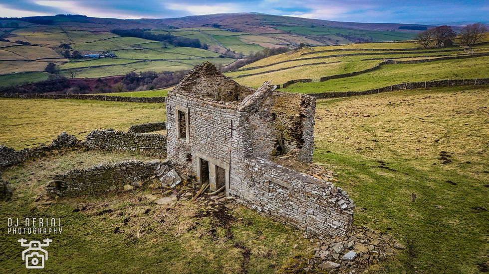
Shepherds House Abandoned Farm Near Eastgate

Shepherds House is an unusual abandoned farmstead in Weardale, as it appears to have been occupied until relatively recently. Unlike many of the older, fully derelict farmhouses in the area, this one still retains some modern features, such as double-glazed windows and newer doors, suggesting it was in use well into the late 20th or early 21st century. Farms like this were once thriving upland settlements, supporting livestock grazing and crop production, but the harsh conditions, economic pressures, and shifting agricultural practices made such isolated farmsteads increasingly difficult to maintain. It is unclear why this particular house was abandoned, but its relatively intact condition suggests it may still have the potential for restoration—a rarity among such buildings in the region.
he contrast between decay and modernity made this site particularly fascinating to photograph. While some farmhouses are reduced to mere stone shells, Shepherds House still feels like it could be inhabited, adding an air of mystery to the location. The drone footage captured its position within the vast Weardale landscape, showing just how isolated it is. The late afternoon light highlighted the textures of the stone walls, making for some dramatic and engaging shots.
Ashy Bank Abandoned House Near Eastgate

Ashy Bank is another example of the many abandoned rural properties scattered across Weardale. Once a working farmhouse, it was home to generations of sheep farmers and agricultural workers who relied on the surrounding land for their livelihood. The harsh conditions, economic downturns, and decline in traditional hill farming led to its eventual abandonment. As farming became less profitable, many of these remote properties were left behind, their occupants moving to larger towns or cities in search of better opportunities. The stone walls remain intact, but the lack of a roof and the encroaching vegetation indicate decades of decay.
Photographing Ashy Bank provided a clear view of its isolation—surrounded by rolling fields and moorland. The cloudy skies and occasional sunlight breaking through created an atmospheric contrast between the ruin and the landscape. The aerial perspective highlighted the building’s footprint, showing how it was once a functional farmstead. Capturing this site reinforced how time has shaped the Weardale countryside, with so many farmhouses succumbing to the elements.
Unnamed Abandoned Farmhouse Near Ashy Bank

This unnamed farmhouse near Ashy Bank is another victim of rural decline, left to the elements as farming in the area became less viable. While records on this particular building are scarce, it likely served as a livestock farm, providing shelter for farmers working the rugged landscape. Unlike some of the larger, more prominent farms, smaller holdings like this often struggled with harsh weather conditions, isolation, and economic pressures. Over the decades, properties like this have been left to crumble, with nature reclaiming what was once a home.
The drone footage gave an incredible view of this little-known ruin, sitting alone in the expansive valley. From the air, it’s clear that nothing remains except the stone walls, which still stand defiantly. With mist rolling in from the hills, the setting felt almost frozen in time. Capturing this spot from above provided a rare opportunity to document a forgotten piece of history, now slowly fading into the landscape.
Airbus A400M Atlas Over Weardale

The Airbus A400M Atlas is a four-engine military transport aircraft, widely used by the Royal Air Force (RAF) for strategic airlift missions. Designed for tactical transport and air-to-air refuelling, it’s capable of carrying heavy loads, vehicles, and troops into remote or hostile environments. The North Pennines and Weardale are often used as low-flying training areas, allowing RAF pilots to practice navigating rugged terrain at high speeds. The sight of this massive aircraft flying low over Weardale is not uncommon, as it replicates operational conditions that crews may encounter in deployment zones.
This was an unexpected moment, but one I was lucky to capture. The A400M thundered through the valley, flying at incredibly low altitude over the Weardale landscape. With only seconds to react, I managed to snap a few shots on my phone as it passed overhead. The contrast between cutting-edge aviation and the ancient hills of Weardale was incredible, making for one of the most exciting and spontaneous moments of the day.
Middlehope Mine

Middlehope Mine was one of Weardale’s most significant lead mines, operating from the 18th to the early 20th century. At its peak, it was part of the extensive lead mining industry that once dominated the North Pennines, providing valuable materials for construction, ammunition, and industrial production. The mine employed hundreds of workers, many of whom lived in nearby mining villages, enduring harsh conditions and physically demanding labour. Declining lead prices and competition from foreign markets led to the mine’s closure, leaving behind a landscape marked by spoil heaps, ruined buildings, and old mine shafts.
Flying the drone over Middlehope Mine provided a unique view of the industrial scars left in the landscape. From above, the old workings, spoil heaps, and abandoned buildings paint a picture of a once-thriving industry. The low sun highlighted the ridges and craters, bringing out details of forgotten structures. The eerie silence of the site made for an atmospheric and fascinating capture, reinforcing how nature is slowly reclaiming this piece of Weardale’s history.
Shield Close – Abandoned Building Near Middlehope Mine

Shield Close is an abandoned building near Middlehope Mine, likely once used by miners or local farmworkers. Its construction suggests it was built in the 19th century, possibly serving as workers’ housing or an outbuilding related to mining operations. Many such buildings were constructed during the peak of lead mining but later fell into disuse as industries declined and people moved away. The harsh climate and economic hardship made survival in these remote locations increasingly difficult, leading to widespread abandonment.
Aerial footage provided clear views of the building’s remains, sitting alone in the bleak landscape of Weardale. The roof has long since collapsed, leaving only the stone shell standing. The surrounding terrain is rugged and untouched, giving the location an eerie sense of isolation. The late afternoon sun created long shadows across the ruin, enhancing the atmospheric feel of the capture. It was a fantastic but haunting location to document.
Abandoned Building Near Dowks Level

This unnamed abandoned building near Dowks Level is another relic of Weardale’s industrial and agricultural past. While records on it are scarce, its proximity to mining sites suggests it may have been linked to lead extraction. Buildings like these were often used for processing materials, storage, or housing for workers. Over time, as the mines shut down, many such buildings were left to collapse and decay, becoming just stone shells scattered across the landscape.
Photographing this forgotten structure gave a powerful sense of history, with the crumbling stone walls blending into the land. The drone captured the isolation perfectly, showing the emptiness that now surrounds the site. From the ground, the rough stonework and scattered debris hinted at years of neglect and abandonment. The site feels lost to time, a reminder of how quickly history fades when left untouched.
Wrapping Up the Day
Today was a remarkable journey through County Durham’s industrial, agricultural, and transport history. From soaring railway viaducts to abandoned farmhouses and lost mines, each location told a different story of the challenges and changes faced by those who lived and worked in these landscapes. The unexpected A400M flyoveradded an extra thrill to the day, proving once again that you never know what you’ll capture on an adventure like this.


Some great shots there David, and great places too. Weardale holds so many gems!