

Old Gang & Beyond – Mining Ruins, Blue Skies & A Hollywood Backdrop in the Yorkshire Dales
- David James
- Apr 2, 2025
- 10 min read
With clear blue skies and crisp spring light, there was only one place I wanted to head today—the Yorkshire Dales, and more specifically, the Old Gang Smelting Mill and the surrounding landscape dotted with lead mining remains. I’d tried to get here a couple of weeks ago, but the area was completely closed off due to filming for a new adaptation of Wuthering Heights—apparently starring Margot Robbie, no less. So, keep your eyes peeled when the film comes out—you might just spot a few real pieces of mining history in the background.
Today made up for the wait. I had a rough plan, but as always in this kind of landscape, I kept seeing ruins and mine workings in the distance, and couldn’t resist heading further and further out. What followed was a proper day of exploration, across a stark and stunning high moorland landscape where history is quite literally built into the ground. Chimneys, flue arches, spoil heaps, collapsed adits, and the skeletal remains of old stone buildings were scattered everywhere—each one telling its own gritty story of hard work, industry, and survival in the elements.
Surrender Smelt Mill Chimney & Flue

The Surrender Smelt Mill, established in 1841, was a significant site in Swaledale's lead mining industry. The mill's flue system, extending approximately 745 metres up the hillside, culminated in a chimney positioned at a higher elevation to safely disperse toxic fumes. This design not only protected workers but also allowed for the recovery of lead deposits that condensed along the flue's interior.
From an aerial perspective, the remnants of the Surrender Smelt Mill reveal the extensive layout of the site. The flue's path is discernible, tracing a line from the mill up to the chimney, illustrating the scale of the operation. The surrounding landscape, now reclaimed by nature, provides a stark contrast to the industrial activity that once dominated the area.
Old Gang Smelting Mill - A Return to Ruins With Time to Spare

Old Gang Smelting Mill, one of the most iconic lead smelting sites in the Yorkshire Dales, dates back to the early 19th century and once formed part of a vast network of lead mining infrastructure on the moors above Swaledale. Operated by the Old Gang Company, the site includes the substantial remains of smelting mills, flues, ore hearths, and stone watercourses. It’s a rare and atmospheric example of industrial heritage preserved in the wild—a landscape built by industry and slowly being reclaimed by nature.
I’d visited before, but last time I was racing against a dying battery and the clock. Today, I came prepared—with enough charge and daylight to do this place justice. From above, the scale of the complex really comes alive, with terraced levels, ruined structures, and spoil heaps spread across the moor. The contrast between the dark stonework and the golden spring grasses made for a perfect palette, and I finally had the time to capture it all—every line, shadow, and forgotten corner of this once-bustling industrial hub.
Hard Level Force - A Quiet Cascade in Dry Conditions

Hard Level Force, found just downstream from the Old Gang smelting area, is usually one of the more dramatic hidden waterfalls in Swaledale, where water drops over layered rock into a shaded gorge below. It’s part of the Hard Level Gill, which once played a key role in draining nearby mine levels. The waterfall often carries the marks of industry, with spoil heaps and stonework nearby, but also offers a real sense of natural seclusion—tucked between the moors and surrounded by rough paths and crags.
Today, after a long stretch of dry and fine weather, the waterfall was running low, with only a gentle trickle flowing down the rock face. While it lacked the usual drama of tumbling water, it gave me the chance to capture the structure of the gorge and the textures of the rock formations clearly. From above, the narrow gill and surrounding landscape still made for a striking view, with the bones of the landscape revealed, even if the water wasn’t putting on its usual show.
Hard Level Gill Bridge - A Sturdy Crossing in a Rugged Landscape
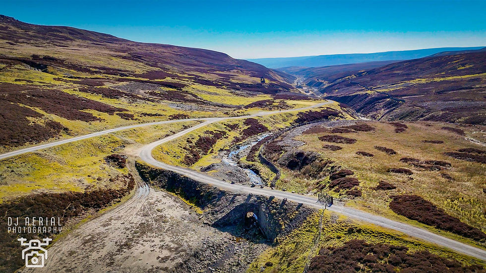
Tucked away near the remains of the Old Gang workings, the Hard Level Gill Bridge is a stone-arched footbridge that spans the gill just above Hard Level Force. Built to serve the lead mining industry in the 19th century, it allowed workers and pack animals to cross the narrow gorge safely, linking various parts of the smelt mill and mine levels. Though modest in size, it’s a brilliant example of practical stonework, still holding strong despite decades of exposure to the elements and the changing landscape of the moor.
From above, the bridge forms a simple yet elegant curve across the narrow stream, blending beautifully with the rugged terrain. The dry conditions today revealed more of the stonework and channel beneath, giving a clear view of how the bridge fits snugly into its surroundings. The drone view shows it as a gateway between two sides of Swaledale’s industrial past, quietly enduring in a landscape shaped by water, stone, and centuries of hard labour.
Ash Pot Gutter - A Channel Through the Heart of Lead Mining Country

Ash Pot Gutter is a man-made watercourse that winds its way across the moorland near the Old Gang area of Swaledale, created to divert and control the flow of water used in the region’s extensive lead mining operations. These artificial leats were essential to the function of washing floors, dressing mills, and powering machinery. Ash Pot Gutter served as part of a larger system feeding water to sites like the Old Gang Smelting Mill, showcasing the impressive engineering efforts of miners working in such remote, rugged terrain.
From the air, Ash Pot Gutter appears as a narrow, snaking line, gently curving across the open moorland. The recent dry weather made the channel easier to trace, with the stone edges and route clearly visible against the grassy landscape. Capturing it from above reveals how it fits into the broader mining network—a small but crucial artery, once used to control water in an unforgiving environment. It’s a subtle but fascinating feature that helps tell the bigger story of how this entire valley was shaped by industry and ingenuity.
Brandy Bottle - A Lone Landmark in the Moorland Wilds

Brandy Bottle is one of those wonderfully unusual names that sticks in your head—and on the ground, it marks a small, isolated building ruin high on the moors near the Old Gang area. Its original purpose isn’t entirely clear, though it may have served as a storehouse, hut or marker linked to nearby lead mining activity. Whatever its use, it now stands as a solitary reminder of human presence in a vast and windswept landscape, slowly crumbling into the ground but still holding its shape.
From the air, Brandy Bottle appears almost like a dot against the endless moor, its low stone walls casting long shadows across the tufts of grass and heather. The isolation is striking - it sits with no nearby structures, just the remnants of old trackways and hints of past movement through the hills. Capturing it from above really highlighted the loneliness and resilience of the building, making it one of the most atmospheric spots of the day.
Moor House Remains - A Fading Echo of Moorland Life

Set out on the high ground beyond the Old Gang smelt mill area, the remains of Moor House offer a poignant glimpse into the past lives of those who once worked and lived in this tough, remote landscape. Likely used by mining workers or shepherds, the building would have provided basic shelter in a harsh and exposed environment. Now, only low stone walls and scattered rubble remain, slowly succumbing to time and weather. It’s one of many forgotten structures that speak to the resilience of those who carved out a living here.
From above, the outline of Moor House is just visible, its footprint blending into the rough texture of the surrounding moor. The drone’s perspective revealed how isolated it truly is, with nothing but empty land stretching in all directions. Its position gives a clear view over the mining scars below, suggesting it once stood as a watchful spot over the valley. There’s a quiet, haunting beauty to it—a final marker of life in a now-silent landscape.
Level House Bridge - A Gateway into Swaledale’s Industrial Past

Level House Bridge is a beautifully preserved stone-arched bridge crossing the beck near the entrance to Swaledale’s lead mining heartland. Located close to the Old Gang smelting area, this bridge would have played a crucial role in transporting materials, ore, and workers between the smelt mills, mine levels, and trackways across the moor. Built in the 19th century, it’s a fine example of functional yet elegant rural engineering, designed to withstand the harsh weather and the weight of industry that once passed over it daily.
Seen from above, Level House Bridge sits snugly in the landscape, its single arch spanning the stream below, surrounded by green slopes and stone walls. The evening light caught the curve of the bridge perfectly, highlighting its solid construction and timeless design. The drone’s view showed how it connects the broader network of paths and structures in the area - a vital crossing point in a landscape once alive with the sounds of Swaledale’s lead mining boom.
Hungry Hushes - A Dramatic Landscape of Industry and Erosion

After exploring the Old Gang area, I made my way towards the Hungry Hushes, perched high above Arkengarthdale. This striking and scarred landscape was formed through a process called ‘hushing’ - an old mining technique where dammed water was suddenly released to strip away topsoil, exposing lead veins beneath. The sheer scale of erosion here is incredible, creating vast channels and gullies that cut deep into the hillside, leaving behind a dramatic, almost alien terrain. It’s a stark reminder of just how much the land was reshaped by centuries of mining activity.
From above, the Hungry Hushes look like a torn landscape, with deep, exposed scars and sharp ridgelines fanning out across the moor. The drone captured the full scope of these earthworks - a complex web of gullies, some broad and shallow, others narrow and deep, all stretching out toward Arkengarthdale below. Despite being the product of industrial force, there’s a wild beauty here, especially in the way the light and shadow dance across the textured ground. It’s a place that feels both desolate and alive—a raw and powerful piece of Swaledale’s mining heritage.
Black Whim - A Subtle Scar on the Moor

Black Whim caught my eye on the map—one of those names that hints at mining history and hidden stories - but when I arrived, there wasn’t a great deal left to see on the ground. Likely the site of a former whimsy or horse-drawn winding mechanism, it would have been used to raise and lower ore or equipment into nearby mine shafts. Over time, structures like this were dismantled or simply collapsed, and at Black Whim, nature has done a good job of reclaiming the site, leaving behind just the faintest traces of industrial activity.
From the air, it was still worth a look. The drone picked out the shallow circular earthworks, possibly the remains of the whim platform, and some faint trackways or spoil edges nearby. It’s one of those locations that feels quiet now but once had purpose, and even though there’s not much left above ground, it still adds to the bigger picture of how this entire moor was once alive with mining movement and machinery. Sometimes, just the name and location are enough to spark the
Bouldershaw House – A Quiet Relic in the Moorland Wind

On the way back to the car, I spotted the weathered structure of Bouldershaw House, standing quietly near the track, looking more like a large, rough stone barn than a former residence. Its solid walls and simple layout suggest it may once have been a farmhouse or shelter linked to the mining or agricultural activity in the area. Now roofless and open to the elements, it has the feel of a building that’s seen hard use and been slowly left behind - a lone sentinel at the edge of Swaledale’s industrial sprawl.
From above, Bouldershaw House is striking in its simplicity, its rectangular footprint standing out cleanly against the textured moorland. The surrounding field patterns and drystone walls hint at a time when this place was part of a much more active landscape. The drone captured the sense of isolation and endurance, with the building facing out across open country, its walls still holding fast against time and weather. It might not be a grand ruin, but it holds a quiet story of resilience in a once-thriving working landscape.
Stang House - A Forgotten Farmstead on the Edge of the Moor

On the drive home, winding through the hills above Arkengarthdale, I spotted a building standing alone on the open moor and had to pull over for a closer look. This was Stang House - an old stone farmhouse, long abandoned but still standing strong against the elements. Its thick walls, multiple rooms, and layout clearly mark it as a former dwelling, not a shooting hut, as some might assume at first glance. The surrounding field boundaries and signs of past farming suggest it once served as a working hill farm, perched high on the ridge known locally as The Stang.
From the air, Stang House is a striking presence, sitting quietly in the landscape with sweeping views across the dalesand the distant fells. The drone revealed the structure’s solid, near-complete form, with gable ends and internal divisions still clearly visible - remarkably intact for a building that’s been left to the moorland wind. Its isolation gives it an atmospheric quality, standing as a solitary echo of a life once lived on the high ground, where farming was tough and the weather even tougher. A proper hidden gem, and a great unexpected find to round off the day.
Wrapping Up the Day
What started with a rough idea quickly turned into a classic Yorkshire Dales adventure - the kind where one location leads to another, and before you know it, you're miles from where you thought you'd end up, surrounded by ruins, history, and sweeping moorland views. The clear skies and crisp light couldn’t have been better for exploring, and after missing out on the Old Gang area during my last visit (thanks to Margot Robbie and Wuthering Heights!), it was brilliant to return with time, battery, and blue skies on my side.
From the industrial scars of Old Gang and Surrender, to the quieter corners like Brandy Bottle, Moor House, and the haunting beauty of the Hungry Hushes, every stop added to the story of this rich, rugged landscape. Even on the way home, there were still surprises—Bouldershaw House caught my eye near the track, and Stang House stood tall on the horizon, refusing to be ignored. These places might not make the headlines, but they’re the ones that stay with you long after the camera’s packed away. A perfect reminder that in the Dales, even without a plan, you’re never short of something incredible to discover.


Comments